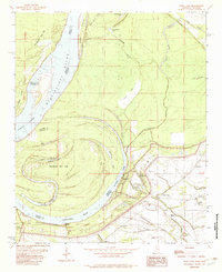
1982 Map of Rena Lara
USGS Topo · Published 1982About this map
Mississippi River oxbows and delta bottomlands dominate this survey of the borderlands between Phillips County, Arkansas, and Coahoma County, Mississippi. The landscape is defined by the winding course of the river, featuring significant landforms like Island No 66 and Jackson Point. Human activity is concentrated along the protected sides of the extensive levee system, where small settlements such as Rena Lara and Hillhouse are situated.
Find a feature on this map
47 named features on this map. Tap any name to fly to it.
Don’t see what you’re looking for? This feature index may not catch every label — zoom into the map to look around manually.
Map Details
Editions of this 1982 Rena Lara Map
This is the sole edition of this map. No revisions or reprints were ever made.
Other maps of this area

1930 · Mellwood
USGS Topo · 1:62,500

1935 · Clarksdale
USGS Topo · 1:62,500

1939 · Farrell
USGS Topo · 1:62,500

1939 · Modoc
USGS Topo · 1:62,500

1939 · Clarksdale
USGS Topo · 1:62,500

1939 · Mellwood
USGS Topo · 1:62,500

1948 · Helena
USGS Topo · 1:250,000

1948 · Modoc
USGS Topo · 1:62,500

1950 · Helena
USGS Topo · 1:250,000

1954 · Mellwood
USGS Topo · 1:62,500