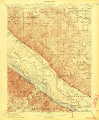
1915 Map of Renault
USGS Topo · Published 1915About this map
The rugged Illinois bluffs overlooking the Mississippi River define this region south of St. Louis, where early French colonial influences persist in the names of the landscape and settlements. Surveyed just before World War I, the map captures a string of river-bottom communities and bluff-top schools serving a dense network of family farms. The St Louis Iron Mountain and Southern and Mobile and Ohio railroads follow the base of the limestone escarpments, connecting river landings with interior towns like Maeystown and Renault.
Find a feature on this map
88 named features on this map. Tap any name to fly to it.
Don’t see what you’re looking for? This feature index may not catch every label — zoom into the map to look around manually.
Map Details
Editions of this 1915 Renault Map
4 editions found

Other maps of this area

1904 · Farmington
USGS Topo · 1:62,500

1906 · Farmington
USGS Topo · 1:62,500

1907 · Weingarten
USGS Topo · 1:62,500

1909 · Weingarten
USGS Topo · 1:62,500

1910 · Waterloo
USGS Topo · 1:62,500

1912 · New Athens
USGS Topo · 1:62,500

1912 · Kimmswick
USGS Topo · 1:62,500

1912 · Baldwin
USGS Topo · 1:62,500

1913 · Waterloo
USGS Topo · 1:62,500

1914 · Baldwin
USGS Topo · 1:62,500