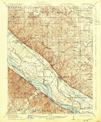
1915 Map of Renault
USGS Topo · Published 1931About this map
Mississippi River bottomlands and steep river bluffs define this 1915 survey of Monroe and Randolph counties in Illinois, along with Ste. Genevieve County in Missouri. The landscape is marked by a complex network of island formations such as Fort Chartres Island, Establishment Island, and Turkey Island, separated from the mainland by narrow chutes like Onemile Race. The era's transportation infrastructure is clearly visible, featuring the St Louis Iron Mountain and Southern RR running along the base of the Bluffs, providing vital connections for settlements like Fults and Modoc.
Find a feature on this map
93 named features on this map. Tap any name to fly to it.
Don’t see what you’re looking for? This feature index may not catch every label — zoom into the map to look around manually.
Map Details
Editions of this 1915 Renault Map
4 editions found

Other maps of this area

1904 · Farmington
USGS Topo · 1:62,500

1906 · Farmington
USGS Topo · 1:62,500

1907 · Weingarten
USGS Topo · 1:62,500

1909 · Weingarten
USGS Topo · 1:62,500

1910 · Waterloo
USGS Topo · 1:62,500

1912 · New Athens
USGS Topo · 1:62,500

1912 · Kimmswick
USGS Topo · 1:62,500

1912 · Baldwin
USGS Topo · 1:62,500

1913 · Waterloo
USGS Topo · 1:62,500

1914 · Baldwin
USGS Topo · 1:62,500