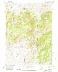
1960 Map of Reno Hill
USGS Topo · Published 1974About this map
Medicine Bow National Forest and the Deer Creek Range National Forest meet in this landscape of high ridges and deep canyons during the early 1960s. The map illustrates a high-altitude livestock economy, where isolated outposts like the Old Tobin Place (also known as the Banner-Bench Cow Camp), Barker Sheep Camp, and the Stewart Ranch provided necessary infrastructure for ranching operations. The topography is defined by sharp elevation changes at Reno Hill and Pine Mtn, with a complex drainage network including Moonshine Canyon, Rainbow Canyon, and Sensebaugh Canyon. Evidence of early resource exploration is visible at a Prospect in the northwestern hills. A network of primitive Jeep Trails and unnamed ruins scattered near Soldier Creek suggest the tenuous nature of settlement and travel in these interior Wyoming highlands.
Find a feature on this map
27 named features on this map. Tap any name to fly to it.
Don’t see what you’re looking for? This feature index may not catch every label — zoom into the map to look around manually.
Map Details
Editions of this 1960 Reno Hill Map
3 editions found
Other maps of this area

1954 · Torrington
USGS Topo · 1:250,000

1955 · Casper
USGS Topo · 1:250,000

1958 · Casper
USGS Topo · 1:250,000

1958 · Torrington
USGS Topo · 1:250,000

1959 · Squaw Spring
USGS Topo · 1:24,000

1959 · Bates Creek Reservoir
USGS Topo · 1:24,000

1960 · Ice Cave Mountain
USGS Topo · 1:24,000

1960 · Banner Mtn
USGS Topo · 1:24,000
1960 · Otter Creek
USGS Topo · 1:24,000

1960 · Reno Hill
USGS Topo · 1:24,000