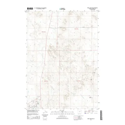
2015 Map of Reno Junction
USGS Topo · Published 2015About this map
Wright and the nearby intersection at Reno Junction anchor the southwestern corner of this Campbell County survey, where residential development meets the high plains of the Powder River Basin. The landscape is defined by the headwaters of the Belle Fourche River system, particularly the branching network of Hay Cr, W Fork Hay Cr, and E Fork Hay Cr which carve through the undulating terrain. To the east, the topography becomes more pronounced with features like Rocky Hill and a distinctive escarpment known as The Jumpoff. Significant drainage patterns are traced through School Section Draw and southward toward the N Prong Little Thunder Cr. The map captures a moment of late twentieth-century growth in the coal-rich region, evident in the residential street names of Wright such as Reno Dr and Winchester Rd, and the functional infrastructure of the Sager Reservoir.
Find a feature on this map
24 named features on this map. Tap any name to fly to it.
Don’t see what you’re looking for? This feature index may not catch every label — zoom into the map to look around manually.
Map Details
Editions of this 2015 Reno Junction Map
This is the sole edition of this map. No revisions or reprints were ever made.
Other maps of this area

1955 · Newcastle
USGS Topo · 1:250,000

1958 · Newcastle
USGS Topo · 1:250,000

1959 · North Star School
USGS Topo · 1:62,500

1960 · Turnercrest
USGS Topo · 1:62,500

1971 · Reno Junction
USGS Topo · 1:24,000

1971 · Reno Reservoir
USGS Topo · 1:24,000

1971 · Little Thunder Reservoir
USGS Topo · 1:24,000
1971 · Eagle Rock
USGS Topo · 1:24,000
1971 · Hilight
USGS Topo · 1:24,000
1972 · Neil Butte
USGS Topo · 1:24,000