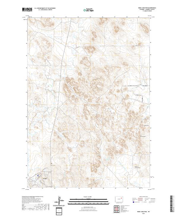
2021 Map of Reno Junction
USGS Topo · Published 2021About this map
Wright and the intersection of Reno Junction anchor this portion of the Powder River Basin, where ranching and energy infrastructure define the high plains landscape. The topography is marked by distinctive drainages and rises, including the steep escarpment of the Jumpoff and the elevation of Rocky Hill. Local water sources are critical to this arid environment, evidenced by the Sager Reservoir and several creek systems like Hay Creek and the North Prong Little Thunder Creek. For those researching regional genealogy, the Wright Cemetery is clearly indicated near the primary settlement area. The map also traces a network of rural roads such as Breene Road and Buffalo Lane, which provide access through the sprawling land divisions of Townships 44 and 45 North.
Find a feature on this map
23 named features on this map. Tap any name to fly to it.
Don’t see what you’re looking for? This feature index may not catch every label — zoom into the map to look around manually.
Map Details
Editions of this 2021 Reno Junction Map
This is the sole edition of this map. No revisions or reprints were ever made.
Other maps of this area

1955 · Newcastle
USGS Topo · 1:250,000

1958 · Newcastle
USGS Topo · 1:250,000

1959 · North Star School
USGS Topo · 1:62,500

1960 · Turnercrest
USGS Topo · 1:62,500

1971 · Reno Junction
USGS Topo · 1:24,000

1971 · Reno Reservoir
USGS Topo · 1:24,000

1971 · Little Thunder Reservoir
USGS Topo · 1:24,000
1971 · Eagle Rock
USGS Topo · 1:24,000
1971 · Hilight
USGS Topo · 1:24,000
1972 · Neil Butte
USGS Topo · 1:24,000