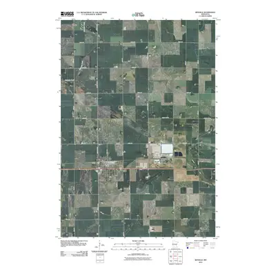
2010 Map of Renville
USGS Topo · Published 2010About this map
Renville sits as the central hub of this agricultural landscape in the early 21st century, defined by a rigid grid of section-line roads and drainage patterns. The town’s social and civic heart is anchored by the Renville Post Office, while the surrounding rural township is dotted with significant local landmarks including Emden Cemetery, Ebenezer Presbyterian Cemetery, and Fairview Cemetery. These burial grounds serve as quiet markers of the area’s pioneer-era settlement and community history. The meandering path of Chetomba Creek provides a rare departure from the straight lines of the survey grid, flowing through the northwestern reaches of the quadrangle. Primary transit is facilitated by a network of thoroughfares like County Hwy-6 and County Hwy-21, which connect the scattered farmsteads to the commercial center in town.
Find a feature on this map
25 named features on this map. Tap any name to fly to it.
Don’t see what you’re looking for? This feature index may not catch every label — zoom into the map to look around manually.
Map Details
Editions of this 2010 Renville Map
This is the sole edition of this map. No revisions or reprints were ever made.
Other maps of this area

1952 · Redwood Falls
USGS Topo · 1:62,500

1953 · New Ulm
USGS Topo · 1:250,000

1957 · New Ulm
USGS Topo · 1:250,000

1958 · New Ulm
USGS Topo · 1:250,000

1965 · Danube
USGS Topo · 1:24,000
1965 · Blomkest
USGS Topo · 1:24,000

1965 · Iverson Lake
USGS Topo · 1:24,000
1965 · Clara City
USGS Topo · 1:24,000

1965 · Sacred Heart
USGS Topo · 1:24,000

1965 · Renville
USGS Topo · 1:24,000