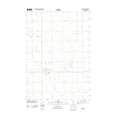
2013 Map of Renville
USGS Topo · Published 2013About this map
Renville serves as the primary hub of this agricultural landscape, centered at the intersection of Us-212 and Main St N. The town's layout reflects its role in the region's transportation and mail networks, with a prominent Po located near the town center. Surrounding the municipality is a vast network of section roads and drainage systems, including the complex County Ditch Number One Hundred Two and County Ditch Number Seventeen A, which manage the prairie hydrology to support the area's farming economy.
Find a feature on this map
31 named features on this map. Tap any name to fly to it.
Don’t see what you’re looking for? This feature index may not catch every label — zoom into the map to look around manually.
Map Details
Editions of this 2013 Renville Map
This is the sole edition of this map. No revisions or reprints were ever made.
Other maps of this area

1952 · Redwood Falls
USGS Topo · 1:62,500

1953 · New Ulm
USGS Topo · 1:250,000

1957 · New Ulm
USGS Topo · 1:250,000

1958 · New Ulm
USGS Topo · 1:250,000

1965 · Danube
USGS Topo · 1:24,000
1965 · Blomkest
USGS Topo · 1:24,000

1965 · Iverson Lake
USGS Topo · 1:24,000
1965 · Clara City
USGS Topo · 1:24,000

1965 · Sacred Heart
USGS Topo · 1:24,000

1965 · Renville
USGS Topo · 1:24,000