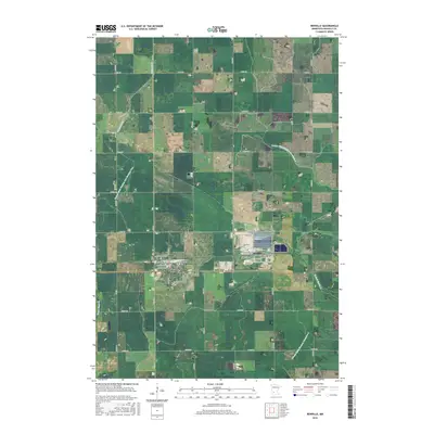
2016 Map of Renville
USGS Topo · Published 2016About this map
Renville serves as the central hub of this agricultural landscape in the mid-2010s, its street grid organized around thoroughfares such as Main St N and Elm Ave SE. The surrounding prairie is defined by a sophisticated system of water management, evidenced by the extensive network of engineered waterways like County Ditch Number One Hundred Two and County Ditch Number Seventeen A that supplement natural drainage from Chetomba Cr.
Find a feature on this map
46 named features on this map. Tap any name to fly to it.
Don’t see what you’re looking for? This feature index may not catch every label — zoom into the map to look around manually.
Map Details
Editions of this 2016 Renville Map
This is the sole edition of this map. No revisions or reprints were ever made.
Other maps of this area

1952 · Redwood Falls
USGS Topo · 1:62,500

1953 · New Ulm
USGS Topo · 1:250,000

1957 · New Ulm
USGS Topo · 1:250,000

1958 · New Ulm
USGS Topo · 1:250,000

1965 · Danube
USGS Topo · 1:24,000
1965 · Blomkest
USGS Topo · 1:24,000

1965 · Iverson Lake
USGS Topo · 1:24,000
1965 · Clara City
USGS Topo · 1:24,000

1965 · Sacred Heart
USGS Topo · 1:24,000

1965 · Renville
USGS Topo · 1:24,000