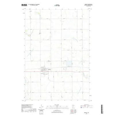
2019 Map of Renville
USGS Topo · Published 2019About this map
The settlement of Renville serves as the central hub of this agricultural landscape in Renville County, organized around a precise grid of rural roads and avenues. The town's layout includes residential streets such as Park Ave W and Colfax Ave NW, bisected by the primary east-west transportation corridor. The surrounding prairie is defined by an extensive water management system, including County Ditch Number One Hundred Two and County Ditch Number Seventeen A, which feed into natural waterways like Chetomba Cr and W Fork Beaver Cr. Local history is preserved in several burial grounds scattered across the townships, including Emden Cem to the north and Fairview Cem located near the town center. The map illustrates a highly productive rural environment where natural creeks like Sacred Heart Cr coexist with a modern drainage network designed to support the region's vast farmstead tracts.
Find a feature on this map
80 named features on this map. Tap any name to fly to it.
Don’t see what you’re looking for? This feature index may not catch every label — zoom into the map to look around manually.
Map Details
Editions of this 2019 Renville Map
This is the sole edition of this map. No revisions or reprints were ever made.
Other maps of this area

1952 · Redwood Falls
USGS Topo · 1:62,500

1953 · New Ulm
USGS Topo · 1:250,000

1957 · New Ulm
USGS Topo · 1:250,000

1958 · New Ulm
USGS Topo · 1:250,000

1965 · Danube
USGS Topo · 1:24,000
1965 · Blomkest
USGS Topo · 1:24,000

1965 · Iverson Lake
USGS Topo · 1:24,000
1965 · Clara City
USGS Topo · 1:24,000

1965 · Sacred Heart
USGS Topo · 1:24,000

1965 · Renville
USGS Topo · 1:24,000