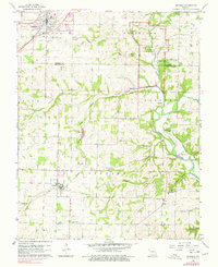
1960 Map of Republic
USGS Topo · Published 1978About this map
Wilsons Creek National Battlefield anchors the eastern edge of this landscape, marking a site of immense historical significance where the Ray House stands as a silent witness to the 1861 conflict. The terrain transitions from the growing rail hub of Republic in the northwest down toward the James River and the rural valley near Boaz. Between these points, a network of family and community history is preserved through numerous burial grounds like Lindsey Cem, Manley Cem, and Edgar Cem.
Find a feature on this map
42 named features on this map. Tap any name to fly to it.
Don’t see what you’re looking for? This feature index may not catch every label — zoom into the map to look around manually.
Map Details
Editions of this 1960 Republic Map
4 editions found
Other maps of this area

1884 · Springfield
USGS Topo · 1:125,000

1886 · Greenfield
USGS Topo · 1:125,000

1886 · Springfield
USGS Topo · 1:125,000

1888 · Greenfield
USGS Topo · 1:125,000

1907 · Forsyth
USGS Topo · 1:125,000

1919 · Halltown
USGS Topo · 1:62,500

1935 · Springfield
USGS Topo · 1:24,000

1936 · Brookline
USGS Topo · 1:24,000

1942 · Aurora
USGS Topo · 1:62,500

1945 · Harrison
USGS Topo · 1:250,000