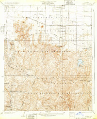
1928 Map of Reseda
USGS Topo · Published 1932About this map
Ex Mission San Fernando lands dominate this mid-1920s landscape, showing the transition of the San Fernando Valley from sprawling rancho tracts into early residential and agricultural plots. The Southern Pacific railroad line runs parallel to the Los Angeles River, supporting settlements like Owensmouth and Reseda. At this time, the Valley floor is remarkably open compared to the dense modern suburbia, with the Reseda Siding and early street grids of Van Owen Street and Ventura Boulevard establishing the area's future arterial framework.
Find a feature on this map
30 named features on this map. Tap any name to fly to it.
Don’t see what you’re looking for? This feature index may not catch every label — zoom into the map to look around manually.
Map Details
Editions of this 1928 Reseda Map
4 editions found
Other maps of this area

1894 · Los Angeles
USGS Topo · 1:62,500

1896 · Santa Monica
USGS Topo · 1:62,500

1898 · Santa Monica
USGS Topo · 1:62,500

1900 · Los Angeles
USGS Topo · 1:62,500

1901 · Southern California Sheet No. 1
USGS Topo · 1:250,000

1902 · Santa Monica
USGS Topo · 1:62,500

1903 · Calabasas
USGS Topo · 1:62,500

1903 · Camulos
USGS Topo · 1:125,000

1904 · Southern California Sheet No. 1
USGS Topo · 1:250,000

1920 · Santa Monica
USGS Topo · 1:62,500