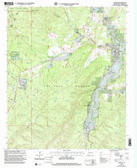
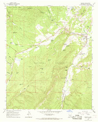
1999 Map of Reserve
USGS Topo · Published 2002About this map
The San Francisco River serves as the central artery for this remote mountain region, where the town of Reserve sits at the confluence with the Tularosa River. This 1999 revision captures a landscape defined by ranching and forest service activity, with numerous named holdings like Griffin Ranch and Rothlisberger Ranch scattered along the drainages of the Saliz Mountains. The map provides detailed placement of early settlements including San Francisco Plaza and Lower San Francisco Plaza, as well as modern infrastructure such as the Rancho Grande Estates. Significant public land management is evident through the crossing boundaries of the Apache National Forest and Gila National Forest, while specific water resources like Starkweather Spring and Hudson Spring mark critical points in the arid terrain for local agriculture and livestock.
Find a feature on this map
78 named features on this map. Tap any name to fly to it.
Don’t see what you’re looking for? This feature index may not catch every label — zoom into the map to look around manually.
Map Details
Editions of this 1999 Reserve Map
This is the sole edition of this map. No revisions or reprints were ever made.
Other maps of this area

1915 · Reserve
USGS Topo · 1:125,000

1918 · Reserve
USGS Topo · 1:125,000

1954 · Clifton
USGS Topo · 1:250,000

1957 · Clifton
USGS Topo · 1:250,000

1958 · Clifton
USGS Topo · 1:250,000

1962 · Clifton
USGS Topo · 1:250,000
1963 · Sign Camp Mountain
USGS Topo · 1:24,000
1963 · Saliz Pass
USGS Topo · 1:24,000
1963 · O Block Canyon
USGS Topo · 1:24,000
1965 · Reserve
USGS Topo · 1:24,000
Featured Places
- Reserve, NM
- Lower San Francisco Plaza, NM
- Rancho Grande Estates, NM
- San Francisco Plaza, NM
- Catron County, NM