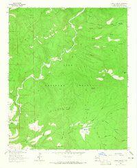
1963 Map of O Block Canyon
USGS Topo · Published 1965About this map
The San Francisco River cuts a deep, winding path through the high country of the Gila National Forest in this 1963 survey. The landscape is defined by the elevation gains of the Saliz Mountains and the Kelly Mountains, where remote infrastructure like the K Kelly Ranch represents the rare human footprint in this interior wilderness. Historical movement through the area is traced via established routes such as the Frying Pan Trail, a Pack Trail, and the Beaverhead Road. The map documents a network of water management features essential for ranching and forest maintenance, including Frisco Plaza Tank No 2, Trail Tank, and Devils Park Tank. Topographical landmarks like Apache Peak and the curiously named Hells Hole Canyon highlight the geographic complexity of the O Block region before modern developments reached this part of New Mexico.
Find a feature on this map
33 named features on this map. Tap any name to fly to it.
Don’t see what you’re looking for? This feature index may not catch every label — zoom into the map to look around manually.
Map Details
Editions of this 1963 O Block Canyon Map
2 editions found
Other maps of this area

1910 · Mogollon
USGS Topo · 1:125,000

1912 · Mogollon
USGS Topo · 1:125,000

1915 · Reserve
USGS Topo · 1:125,000

1918 · Reserve
USGS Topo · 1:125,000

1954 · Clifton
USGS Topo · 1:250,000

1957 · Clifton
USGS Topo · 1:250,000

1958 · Clifton
USGS Topo · 1:250,000

1962 · Clifton
USGS Topo · 1:250,000

1963 · Bearwallow Mountain
USGS Topo · 1:24,000
1963 · Sign Camp Mountain
USGS Topo · 1:24,000