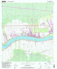
1999 Map of Reserve
USGS Topo · Published 2000About this map
The Mississippi River creates a wide, sweeping bend through this stretch of the river parishes, defining the economic and social geography of the region. On the northern bank, the industrial and residential corridors of Reserve and Garyville are connected by a network of canals like the Godchaux Canal and Reserve Canal, reflecting the area's transition from agricultural foundations to industrial utility. The riverfront is dotted with significant landmarks including the San Francisco Plantation and Lions, while the southern bank maintains a more rural character around the settlements of Edgard and Lucy.
Find a feature on this map
27 named features on this map. Tap any name to fly to it.
Don’t see what you’re looking for? This feature index may not catch every label — zoom into the map to look around manually.
Map Details
Editions of this 1999 Reserve Map
This is the sole edition of this map. No revisions or reprints were ever made.
Other maps of this area

1891 · Hahnville
USGS Topo · 1:62,500

1892 · Lac Des Allemands
USGS Topo · 1:62,500

1892 · Mount Airy
USGS Topo · 1:62,500

1892 · Bonnet Carre
USGS Topo · 1:62,500

1932 · Lac Des Allemands NW
USGS Topo · 1:31,680

1932 · Hahnville NW
USGS Topo · 1:31,680

1932 · Lac Des Allemands NE
USGS Topo · 1:31,680

1935 · Laplace
USGS Topo · 1:31,680

1936 · Hahnville
USGS Topo · 1:31,680

1936 · Ruddock
USGS Topo · 1:31,680