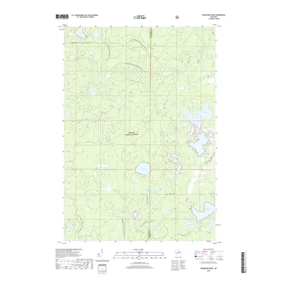
2018 Map of Reservoir Pond
USGS Topo · Published 2018About this map
Nicolet National Forest dominates this landscape on the boundary of Langlade and Oconto counties. The area is defined by an intricate network of glacial lakes and wetlands, ranging from the large Reservoir Pond and Horn Lake in the east to the more secluded Ada Lake and Glade Lake in the north. The hydrology is centered on the S Br Oconto River and McCaslin Brook, with the Jones Spring Impoundment and several named springs like McCaslin Spring and Barney Spring indicating a terrain deeply shaped by groundwater. Modern recreational use is evident through the extensive Snowmobile Trail LKLN Langlade (Snow) which traverses the northern and western sections, connecting the various lake basins including Sasacat Lake and Upper Hiwanka Lake. Small interior lakes such as Fanny Lake, Mary Lake, and Shay Lake highlight the dense, forested character of this Northwoods region.
Find a feature on this map
37 named features on this map. Tap any name to fly to it.
Don’t see what you’re looking for? This feature index may not catch every label — zoom into the map to look around manually.
Map Details
Editions of this 2018 Reservoir Pond Map
This is the sole edition of this map. No revisions or reprints were ever made.
Other maps of this area

1942 · Wabeno
USGS Topo · 1:48,000

1942 · Pearson
USGS Topo · 1:48,000

1950 · Wabeno
USGS Topo · 1:48,000

1950 · Lily
USGS Topo · 1:48,000

1951 · Wabeno
USGS Topo · 1:48,000

1952 · White Lake
USGS Topo · 1:48,000

1952 · Langlade
USGS Topo · 1:48,000

1954 · Iron Mountain
USGS Topo · 1:250,000

1959 · Iron Mountain
USGS Topo · 1:250,000
1972 · Wabeno
USGS Topo · 1:24,000