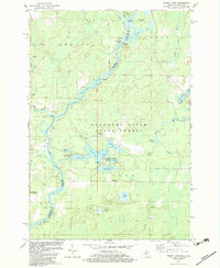
1982 Map of Resort Lake
USGS Topo · Published 1983About this map
The Menominee River serves as the primary geographic and political boundary in this early 1980s landscape, winding past Sixty Islands and separating Michigan from Wisconsin. This area is defined by the extensive Escanaba River State Forest and the Wausaukee State Forest, highlighting a region dedicated to timber and recreation. The Resort Lake vicinity is particularly dense with small water bodies including Bass Lake, East Lake, and Baker Lake, which anchor the Shakey Lakes County Park.
Find a feature on this map
45 named features on this map. Tap any name to fly to it.
Don’t see what you’re looking for? This feature index may not catch every label — zoom into the map to look around manually.
Map Details
Editions of this 1982 Resort Lake Map
This is the sole edition of this map. No revisions or reprints were ever made.
Other maps of this area

1939 · Pembine
USGS Topo · 1:48,000

1942 · Wausaukee
USGS Topo · 1:48,000

1947 · Pembine
USGS Topo · 1:48,000

1947 · Wausaukee
USGS Topo · 1:48,000

1949 · Stephenson
USGS Topo · 1:48,000

1954 · Escanaba
USGS Topo · 1:250,000

1957 · Escanaba
USGS Topo · 1:250,000

1958 · Escanaba
USGS Topo · 1:250,000

1963 · Pembine
USGS Topo · 1:62,500

1963 · Powers
USGS Topo · 1:62,500