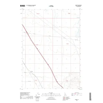
2020 Map of Reverse
USGS Topo · Published 2020About this map
Reverse sits at a crossroads of high desert transport history in this corner of Elmore County. The landscape is defined by the diagonal transit of the Old Oregon Trail Rd, a modern artery tracing a path of immense historical significance for westward migration. Nearby, the infrastructure of regional agriculture and travel is evident through routes like Beet Dump Rd, Old Hwy 30, and Billy Rio Loop Rd, which crisscross the arid terrain between the basalt-rimmed drainages of Dry Cr and Hot Springs Cr. In the northeast corner, the Hot Springs Cr Reservoir provides a critical water source in an otherwise dry landscape. The map captures the specialized road network used to move crops and livestock, illustrating how modern commerce in this part of Idaho still follows the geometric and topographic logic of the original overland trails.
Find a feature on this map
16 named features on this map. Tap any name to fly to it.
Don’t see what you’re looking for? This feature index may not catch every label — zoom into the map to look around manually.
Map Details
Editions of this 2020 Reverse Map
This is the sole edition of this map. No revisions or reprints were ever made.
Other maps of this area

1892 · Mountain Home
USGS Topo · 1:125,000

1892 · Camas Prairie
USGS Topo · 1:125,000

1893 · Mountain Home
USGS Topo · 1:125,000

1893 · Camas Prairie
USGS Topo · 1:125,000

1947 · Indian Cove
USGS Topo · 1:24,000

1947 · Hammett
USGS Topo · 1:24,000

1947 · Sand Dunes
USGS Topo · 1:24,000

1948 · Sand Dunes
USGS Topo · 1:24,000

1948 · Hammett
USGS Topo · 1:24,000

1948 · Indian Cove
USGS Topo · 1:24,000