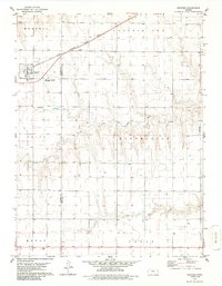
1979 Map of Rexford
USGS Topo · Published 1986About this map
Rexford serves as the primary hub of this High Plains landscape, situated at the intersection of the Chicago Rock Island and Pacific railroad and regional roadways. The topography is defined by the headwaters and drainage of the North Fork Solomon River and the South Fork Solomon River, which carve distinct valleys across the plains. This 1970s survey captures the agricultural and infrastructure layout of the region, including the Rexford Cem south of the main townsite and the prominent Radio Tower in the southern section of the quadrangle. Significant markers of local industry and utility are visible, such as a Gravel Pit and the Sewage Disposal Ponds. The map also delineates the border between Thomas County and Sheridan County, providing a clear record of property and political boundaries during this era.
Find a feature on this map
17 named features on this map. Tap any name to fly to it.
Don’t see what you’re looking for? This feature index may not catch every label — zoom into the map to look around manually.
Map Details
Editions of this 1979 Rexford Map
2 editions found
Other maps of this area

1951 · Selden
USGS Topo · 1:62,500

1951 · Achilles
USGS Topo · 1:62,500

1954 · Goodland
USGS Topo · 1:250,000

1956 · Goodland
USGS Topo · 1:250,000

1957 · Goodland
USGS Topo · 1:250,000

1978 · Selden
USGS Topo · 1:24,000

1978 · Achilles SE
USGS Topo · 1:24,000

1978 · Selden SW
USGS Topo · 1:24,000

1979 · Menlo
USGS Topo · 1:24,000

1979 · Rexford
USGS Topo · 1:24,000