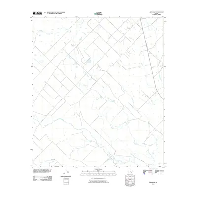
2010 Map of Rexville
USGS Topo · Published 2010About this map
San Bernard River and its intricate network of tributaries define the agricultural landscape of Austin County in this 2010 survey. The settlement of Rexville serves as a central point in a region dominated by a grid of rural routes, including Rexville Rd and Mieth Rd, which connect the scattered farmsteads and fields of the Texas coastal plain. The drainage patterns of East Bernard Creek, Little Bernard Creek, and Middle Bernard Creek illustrate the low-lying, water-rich environment that has shaped local land use for generations. This map provides a clear view of the rural infrastructure at the beginning of the 21st century, showing how modern roads like FM 3013 and FM 3538 integrate with older family-named thoroughfares such as Klopsteck Rd and Beckendorff Rd, reflecting the deep-rooted local history of the Sealy area.
Find a feature on this map
38 named features on this map. Tap any name to fly to it.
Don’t see what you’re looking for? This feature index may not catch every label — zoom into the map to look around manually.
Map Details
Editions of this 2010 Rexville Map
This is the sole edition of this map. No revisions or reprints were ever made.
Other maps of this area

1953 · Seguin
USGS Topo · 1:250,000

1956 · Bellville
USGS Topo · 1:62,500

1956 · Sealy
USGS Topo · 1:62,500

1956 · Wallis
USGS Topo · 1:62,500

1957 · Eagle Lake
USGS Topo · 1:62,500

1958 · Seguin
USGS Topo · 1:250,000

1960 · Lissie
USGS Topo · 1:24,000

1960 · Wallis
USGS Topo · 1:24,000

1960 · San Felipe
USGS Topo · 1:24,000
1960 · East Bernard
USGS Topo · 1:24,000