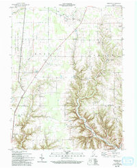
1959 Map of Rexville
USGS Topo · Published 1993About this map
Rexville stands at the center of this rural landscape where the agricultural fields of Shelby and Brown townships meet the deeply incised valleys of the Indian Kentuck Creek watershed. The map records a dense network of family and community history, evidenced by an unusual concentration of burial sites such as the Daubepheyer Cem, Old Westfork Cem, and Witham Cem (Bachman Cem). To the west, the boundary of the Jefferson Proving Ground creates a sharp line between the open farmland and the restricted military terrain. Cultural landmarks like the Camp Meeting Ground and small country sanctuaries including Shelby Ch and Jefferson Ch suggest the enduring social structures of this southeastern Indiana region during the late 1950s.
Find a feature on this map
46 named features on this map. Tap any name to fly to it.
Don’t see what you’re looking for? This feature index may not catch every label — zoom into the map to look around manually.
Map Details
Editions of this 1959 Rexville Map
Other maps of this area

1946 · Versailles
USGS Topo · 1:24,000

1946 · Milan
USGS Topo · 1:24,000

1953 · Cincinnati
USGS Topo · 1:250,000

1956 · Clifty Falls
USGS Topo · 1:24,000

1956 · Bennington
USGS Topo · 1:24,000

1956 · Canaan
USGS Topo · 1:24,000

1956 · Louisville
USGS Topo · 1:250,000

1957 · Cincinnati
USGS Topo · 1:250,000

1959 · Holton
USGS Topo · 1:24,000

1959 · San Jacinto
USGS Topo · 1:24,000