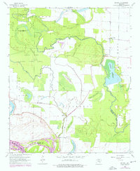
1964 Map of Reydell
USGS Topo · Published 1976About this map
The Arkansas River meanders across the southern edge of this delta landscape, defined by a complex network of oxbow lakes and wetlands. The settlement of Reydell serves as a focal point near the center, situated between Reydell Brake and the twisting course of Little Bayou Meto. To the north, the Bayou Meto State Game Area preserves a significant portion of the bottomlands, where Goose Lake and Buckingham Flat reflect the natural drainage patterns of the region. Evidence of early rural life is found in scattered landmarks such as Cannon Ch and Hannaberry Sch. Genealogists will find several burial grounds including Abbey Cem, Langford Cem, and Lemmons Cem, which mark the historical footprint of the families who farmed this alluvial plain. The presence of Rodgers Reservoir and a Pumping Station indicate the ongoing importance of water management for local agriculture.
Find a feature on this map
37 named features on this map. Tap any name to fly to it.
Don’t see what you’re looking for? This feature index may not catch every label — zoom into the map to look around manually.
Map Details
Editions of this 1964 Reydell Map
2 editions found
Other maps of this area

1935 · Varner
USGS Topo · 1:62,500

1935 · Gillett
USGS Topo · 1:62,500

1941 · De Witt
USGS Topo · 1:62,500

1941 · Goldman
USGS Topo · 1:62,500

1948 · Helena
USGS Topo · 1:250,000

1950 · Helena
USGS Topo · 1:250,000

1954 · De Witt
USGS Topo · 1:62,500

1955 · Helena
USGS Topo · 1:250,000

1959 · Helena
USGS Topo · 1:250,000

1960 · Helena
USGS Topo · 1:250,000