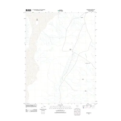
2011 Map of Reynard
USGS Topo · Published 2011About this map
Smoke Creek Desert dominates the western edge of this Washoe County landscape, giving way to an arid basin characterized by intermittent drainage and deep-cut canyons. The settlement of Reynard and the community of Smoke Creek are the primary points of human presence in this high-desert environment, positioned along a network of sparse roads and rail paths. Eastward, the terrain rises into a series of significant geological formations including Wild Horse Canyon, Pole Canyon, and Rough Canyon. These canyons, alongside Wild Horse Creek and Lost Creek, trace the natural hydrology of the Great Basin, where seasonal water flow has carved the land. This 2011 survey captures the area before modern expansion, showing the relationship between small outposts and the vast, unpopulated stretches of the Nevada desert.
Find a feature on this map
8 named features on this map. Tap any name to fly to it.
Don’t see what you’re looking for? This feature index may not catch every label — zoom into the map to look around manually.
Map Details
Editions of this 2011 Reynard Map
This is the sole edition of this map. No revisions or reprints were ever made.
Other maps of this area

1886 · Granite Range
USGS Topo · 1:250,000

1894 · Granite Range
USGS Topo · 1:250,000

1955 · Lovelock
USGS Topo · 1:250,000

1959 · Lovelock
USGS Topo · 1:250,000

1965 · Fox Range
USGS Topo · 1:62,500

1980 · Salt Marsh
USGS Topo · 1:24,000
1980 · Sand Pass
USGS Topo · 1:24,000

1980 · Hog Spring
USGS Topo · 1:24,000

1980 · Smith Canyon
USGS Topo · 1:24,000
1981 · Sheepshead Spring
USGS Topo · 1:24,000