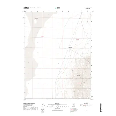
2018 Map of Reynard
USGS Topo · Published 2018About this map
The Smoke Creek Desert dominates the western expanse of this high-desert landscape in northwestern Nevada. The terrain transitions sharply from the arid flats of the desert basin into the steep, deeply dissected western slopes of the Fox Range, which rises in the southeast corner of the map. This elevation change is carved by seasonal drainages such as Wild Horse Canyon, Pole Canyon, and Rough Canyon, showing the erosional patterns typical of the Great Basin's mountain-and-valley systems. Water is a defining but sparse presence, represented by the ephemeral course of Smoke Creek and small tributaries like Wild Horse Cr and Lost Cr. This 2018 survey provides a clear look at the topographic boundaries between the playa and the adjacent peaks, reflecting a remote region defined more by its natural geology and watershed patterns than by human development.
Find a feature on this map
12 named features on this map. Tap any name to fly to it.
Don’t see what you’re looking for? This feature index may not catch every label — zoom into the map to look around manually.
Map Details
Editions of this 2018 Reynard Map
This is the sole edition of this map. No revisions or reprints were ever made.
Other maps of this area

1886 · Granite Range
USGS Topo · 1:250,000

1894 · Granite Range
USGS Topo · 1:250,000

1955 · Lovelock
USGS Topo · 1:250,000

1959 · Lovelock
USGS Topo · 1:250,000

1965 · Fox Range
USGS Topo · 1:62,500

1980 · Salt Marsh
USGS Topo · 1:24,000
1980 · Sand Pass
USGS Topo · 1:24,000

1980 · Hog Spring
USGS Topo · 1:24,000

1980 · Smith Canyon
USGS Topo · 1:24,000
1981 · Sheepshead Spring
USGS Topo · 1:24,000