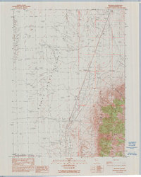
1990 Map of Reynard
USGS Topo · Published 1990About this map
The Smoke Creek Desert dominates the western half of this Nevada landscape, transitioning into the steep, deeply incised drainages of the Fox Range to the east. This 1990 provisional survey records a sparse high-desert environment where water sources like Hog Spring and the Salt Marsh were vital for survival. The settlement pattern is minimal, represented by the rail siding at Reynard and the historic Smoke Creek (Site), suggesting a terrain defined more by transit and resource extraction than permanent residency. Evidence of human activity is found in the scattered Prospects and a modern Radio Facility near the northern boundary. The southern edge of the map includes a portion of the Pyramid Lake Indian Reservation, while the rugged eastern terrain is marked by topographic features like Wild Horse Canyon, Pole Canyon, and Rough Canyon.
Find a feature on this map
17 named features on this map. Tap any name to fly to it.
Don’t see what you’re looking for? This feature index may not catch every label — zoom into the map to look around manually.
Map Details
Editions of this 1990 Reynard Map
This is the sole edition of this map. No revisions or reprints were ever made.
Other maps of this area

1886 · Granite Range
USGS Topo · 1:250,000

1894 · Granite Range
USGS Topo · 1:250,000

1955 · Lovelock
USGS Topo · 1:250,000

1959 · Lovelock
USGS Topo · 1:250,000

1965 · Fox Range
USGS Topo · 1:62,500

1980 · Salt Marsh
USGS Topo · 1:24,000
1980 · Sand Pass
USGS Topo · 1:24,000

1980 · Hog Spring
USGS Topo · 1:24,000

1980 · Smith Canyon
USGS Topo · 1:24,000
1981 · Sheepshead Spring
USGS Topo · 1:24,000