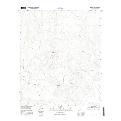
2016 Map of Reynolds Bend
USGS Topo · Published 2016About this map
Reynolds Bend sits within a dramatic loop of the Clear Fork Brazos River, a landscape defined by sharp elevation changes and dry-country water management. The terrain is marked by distinctive formations such as Hittson Bluff, Buzzard Peak, and several deep cuts including Lime Kiln Canyon and Graveyard Canyon. Local infrastructure revolves around the ranching economy, with named landmarks like Stone Ranch Rd and Matthews Ranch Rd connecting isolated points across the rugged topography.
Find a feature on this map
35 named features on this map. Tap any name to fly to it.
Don’t see what you’re looking for? This feature index may not catch every label — zoom into the map to look around manually.
Map Details
Editions of this 2016 Reynolds Bend Map
This is the sole edition of this map. No revisions or reprints were ever made.
Other maps of this area

1892 · Albany
USGS Topo · 1:125,000

1893 · Albany
USGS Topo · 1:125,000

1954 · Abilene
USGS Topo · 1:250,000

1954 · Wichita Falls
USGS Topo · 1:250,000

1958 · Wichita Falls
USGS Topo · 1:250,000

1958 · Abilene
USGS Topo · 1:250,000

1965 · Collins Creek
USGS Topo · 1:24,000
1965 · Antelope Hills
USGS Topo · 1:24,000

1965 · Fort Griffin
USGS Topo · 1:24,000

1965 · Reynolds Bend NW
USGS Topo · 1:24,000
Featured Places
- Reynolds Crossing, TX
- Gentry Crossing, TX
- Bartholomew Crossing, TX
- Hayford Crossing, TX
- McKeichan Crossing, TX