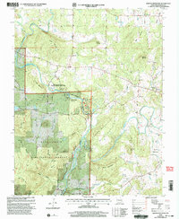
2000 Map of Rhodes Mountain
USGS Topo · Published 2003About this map
The St Francis River cuts a complex path through the heart of this landscape, forming notable geologic features like the Tiemann Shut-In and Mud Creek Shut-In. This area in the St. Francois Mountains is defined by a history of extraction and preservation, where the Millstream Gardens State Conservation Area and Silver Mine Rec Area now occupy lands once busy with prospecting. Evidence of the region's mining heritage is clearly marked at the Silver Mine and Apex Mine, as well as the aptly named Tin Mine Mountain.
Find a feature on this map
60 named features on this map. Tap any name to fly to it.
Don’t see what you’re looking for? This feature index may not catch every label — zoom into the map to look around manually.
Map Details
Editions of this 2000 Rhodes Mountain Map
This is the sole edition of this map. No revisions or reprints were ever made.
Other maps of this area

1926 · Des Arc
USGS Topo · 1:62,500

1929 · Des Arc
USGS Topo · 1:62,500

1930 · Coldwater
USGS Topo · 1:62,500

1937 · Ironton
USGS Topo · 1:48,000

1939 · Fredericktown
USGS Topo · 1:48,000

1945 · Ironton
USGS Topo · 1:62,500

1946 · Ironton
USGS Topo · 1:62,500

1947 · Fredericktown
USGS Topo · 1:62,500

1949 · Rolla
USGS Topo · 1:250,000

1949 · Coldwater
USGS Topo · 1:62,500