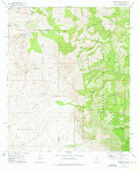
1972 Map of Rhodes Peak
USGS Topo · Published 1975About this map
Magma Mine and the Bunker Hill Mine anchor the western edge of this 1970s survey, highlighting the mineral-driven history of the high desert along the Pinal Co Graham Co boundary. The landscape is dominated by the Galiuro Mountains, where steep drainages like Pipestem Canyon and North Field Canyon carve through the Galiuro Wilderness.
Find a feature on this map
49 named features on this map. Tap any name to fly to it.
Don’t see what you’re looking for? This feature index may not catch every label — zoom into the map to look around manually.
Map Details
Editions of this 1972 Rhodes Peak Map
2 editions found
Other maps of this area

1911 · Winkelman
USGS Topo · 1:125,000

1913 · Winkelman
USGS Topo · 1:125,000

1938 · Galiuro Mts
USGS Topo · 1:48,000

1938 · Klondyke
USGS Topo · 1:48,000

1943 · Galiuro Mts
USGS Topo · 1:62,500

1943 · Klondyke
USGS Topo · 1:62,500

1948 · Clark Ranch
USGS Topo · 1:24,000

1948 · Mammoth
USGS Topo · 1:62,500

1948 · Peppersauce Wash
USGS Topo · 1:24,000

1949 · Clark Ranch
USGS Topo · 1:24,000