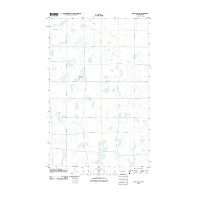
2011 Map of Rice Lake NW
USGS Topo · Published 2011About this map
Flying S Ranch Landing Strip serves as a lone aeronautical landmark in this prairie landscape, situated near the intersection of 268th St NW and 37th Ave SW. The terrain is defined by a dense concentration of small glacial potholes and wetlands, creating a complex hydrologic pattern across the Ward County countryside. A rigid grid of section-line roads, including 93rd Ave SW and 296th St NW, segments the territory, reflecting the enduring legacy of the Public Land Survey System in North Dakota. This 2011 survey captures the area at a time when traditional agricultural land use and natural water features dominated the geography, with many small water bodies dispersed between corridors like 11th Ave SW.
Find a feature on this map
22 named features on this map. Tap any name to fly to it.
Don’t see what you’re looking for? This feature index may not catch every label — zoom into the map to look around manually.
Map Details
Editions of this 2011 Rice Lake NW Map
This is the sole edition of this map. No revisions or reprints were ever made.
Other maps of this area

1950 · Des Lacs
USGS Topo · 1:24,000

1954 · Minot
USGS Topo · 1:250,000

1958 · Minot
USGS Topo · 1:250,000

1980 · Minot
USGS Topo · 1:100,000

1980 · Plaza SE
USGS Topo · 1:24,000

1980 · Rice Lake NW
USGS Topo · 1:24,000

1980 · Tagus SE
USGS Topo · 1:24,000
1980 · Berthold
USGS Topo · 1:24,000
1980 · Underdahl Lake
USGS Topo · 1:24,000
1980 · Mork Lake
USGS Topo · 1:24,000