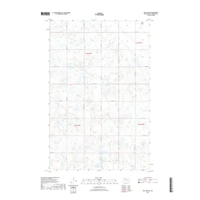
2017 Map of Rice Lake NW
USGS Topo · Published 2017About this map
The rolling pothole prairie of Ward County is meticulously documented in this 2017 survey, where a complex network of seasonal wetlands and small water bodies dominates the terrain. Lloyds Coulee in the northeast corner serves as one of the few named drainage features in this glaciated landscape, which is otherwise defined by an exacting grid of section lines and gravel roads. Local travel is facilitated by a numbered grid including 4th Ave NW, 20th Ave SW, and Co Hwy 11, reflecting the organized agricultural township structure of North Dakota’s interior. The map illustrates the persistent intersection of modern rural infrastructure with the natural depressions of the Drift Prairie, providing a clear view of land use patterns at the start of the 21st century.
Find a feature on this map
21 named features on this map. Tap any name to fly to it.
Don’t see what you’re looking for? This feature index may not catch every label — zoom into the map to look around manually.
Map Details
Editions of this 2017 Rice Lake NW Map
This is the sole edition of this map. No revisions or reprints were ever made.
Other maps of this area

1950 · Des Lacs
USGS Topo · 1:24,000

1954 · Minot
USGS Topo · 1:250,000

1958 · Minot
USGS Topo · 1:250,000

1980 · Minot
USGS Topo · 1:100,000

1980 · Plaza SE
USGS Topo · 1:24,000

1980 · Rice Lake NW
USGS Topo · 1:24,000

1980 · Tagus SE
USGS Topo · 1:24,000
1980 · Berthold
USGS Topo · 1:24,000
1980 · Underdahl Lake
USGS Topo · 1:24,000
1980 · Mork Lake
USGS Topo · 1:24,000