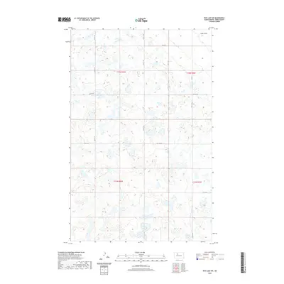
2020 Map of Rice Lake NW
USGS Topo · Published 2020About this map
Lloyds Coulee cuts through the northeast corner of this Ward County landscape, a territory defined by an intricate network of wetlands and prairie potholes. This modern topographic survey illustrates the enduring Section Line road system that organizes the North Dakota plains, with corridors like 282nd St NW and 254th St NW forming a rigid grid across the undulating terrain. The drainage patterns and water retention areas shown here are characteristic of the glaciated plains, where countless small basins dot the townships of T155N R86W and T154N R85W. While the area is dominated by agricultural land and natural water features, the presence of Co Hwy 11 serves as a primary north-south artery connecting these rural sections. Researchers of local geography will find a clear record of the intersection between the natural hydrology of the coulee systems and the human-imposed grid of the Public Land Survey System.
Find a feature on this map
16 named features on this map. Tap any name to fly to it.
Don’t see what you’re looking for? This feature index may not catch every label — zoom into the map to look around manually.
Map Details
Editions of this 2020 Rice Lake NW Map
This is the sole edition of this map. No revisions or reprints were ever made.
Other maps of this area

1950 · Des Lacs
USGS Topo · 1:24,000

1954 · Minot
USGS Topo · 1:250,000

1958 · Minot
USGS Topo · 1:250,000

1980 · Minot
USGS Topo · 1:100,000

1980 · Plaza SE
USGS Topo · 1:24,000

1980 · Rice Lake NW
USGS Topo · 1:24,000

1980 · Tagus SE
USGS Topo · 1:24,000
1980 · Berthold
USGS Topo · 1:24,000
1980 · Underdahl Lake
USGS Topo · 1:24,000
1980 · Mork Lake
USGS Topo · 1:24,000