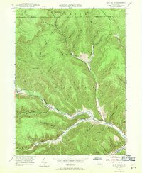
1948 Map of Rich Valley
USGS Topo · Published 1970About this map
Sinnemahoning Creek carves a deep valley through the township of Shippen and the surrounding highlands of Cameron and McKean Counties in this mid-century topographic survey. The landscape is defined by its drainage patterns, where countless runs and hollows such as Waldy Run and Sixmile Hollow feed into the larger watercourses. Small settlements and local landmarks dot the valleys, including the hamlet of Lockwood and the North Creek Chapel, while the Pennsylvania railroad line follows the contours of the creek beds to navigate the steep terrain.
Find a feature on this map
56 named features on this map. Tap any name to fly to it.
Don’t see what you’re looking for? This feature index may not catch every label — zoom into the map to look around manually.
Map Details
Editions of this 1948 Rich Valley Map
4 editions found

Other maps of this area

1941 · Benezette
USGS Topo · 1:62,500

1943 · Benezette
USGS Topo · 1:62,500

1945 · Driftwood
USGS Topo · 1:48,000

1945 · Cameron
USGS Topo · 1:24,000

1947 · Cameron
USGS Topo · 1:24,000

1948 · Crosby
USGS Topo · 1:62,500

1948 · Emporium
USGS Topo · 1:62,500

1948 · Keating Summit
USGS Topo · 1:24,000

1948 · Emporium
USGS Topo · 1:24,000

1948 · Wildwood Fire Tower
USGS Topo · 1:24,000
Featured Places
- Norwich Township, PA
- Weber City, Shippen Township
- Shippen Township, PA
- Lockwood, Shippen Township
- Lawn View, Shippen Township