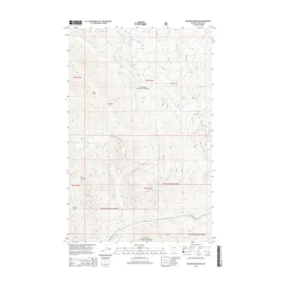
2014 Map of Richards Mountain
USGS Topo · Published 2014About this map
Kootenai National Forest dominates this section of Lincoln County, defined by a complex drainage system feeding into the larger valley. High points such as Dunn Peak and Richards Mtn provide the primary vertical relief, while the lower elevations are carved by numerous watercourses including Wyoma Cr, Alder Cr, and Dunn Cr. This 2014 survey illustrates the intricate network of forest management routes, most notably Natl Forest Develop Road 97 Rd and the more established Wolf Creek Rd near the southern boundary. To the southwest, Mt Sterling overlooks Sterling Gulch, highlighting the local naming conventions that tie specific peaks to their adjacent drainages. The map serves as a detailed record of high-country geography in the early 21st century, showing how modern forestry access interlaces with the natural flow of Wolf Cr and Backus Cr.
Find a feature on this map
21 named features on this map. Tap any name to fly to it.
Don’t see what you’re looking for? This feature index may not catch every label — zoom into the map to look around manually.
Map Details
Editions of this 2014 Richards Mountain Map
This is the sole edition of this map. No revisions or reprints were ever made.
Other maps of this area

1920 · Jennings
USGS Topo · 1:125,000

1935 · Thompson Lakes
USGS Topo · 1:96,000

1942 · Thompson Lakes
USGS Topo · 1:125,000

1957 · Kalispell
USGS Topo · 1:250,000

1960 · Kalispell
USGS Topo · 1:250,000

1961 · Kalispell
USGS Topo · 1:250,000

1963 · Wolf Prairie
USGS Topo · 1:24,000

1963 · Warland Peak
USGS Topo · 1:24,000

1963 · Cripple Horse Mountain
USGS Topo · 1:24,000
1963 · Tony Peak
USGS Topo · 1:24,000