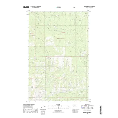
2020 Map of Richards Mountain
USGS Topo · Published 2020About this map
Kootenai National Forest lands dominate this part of Lincoln County, defined by the high elevations of Richards Mountain and Dunn Peak. The drainage patterns show a complex network of creeks including Wolf Creek in the south and the northern reaches of Dunn Creek, which flows past the deep ravine of Snag Gulch. This 2020 survey records the intricate system of Forest Service access, notably Natl Forest Develop Road 97 RD and Natl Forest Develop Road 4916 RD, which navigate the steep terrain between Mt Sterling and Hornet Ridge. Evidence of fire management and observation is visible at Sugarloaf Lookout, positioned near the eastern boundary. The map provides a detailed look at the land's topographical character, from the depths of Sterling Gulch to the high ridges that separate the various forks of Richards Creek and Backus Creek.
Find a feature on this map
25 named features on this map. Tap any name to fly to it.
Don’t see what you’re looking for? This feature index may not catch every label — zoom into the map to look around manually.
Map Details
Editions of this 2020 Richards Mountain Map
This is the sole edition of this map. No revisions or reprints were ever made.
Other maps of this area

1920 · Jennings
USGS Topo · 1:125,000

1935 · Thompson Lakes
USGS Topo · 1:96,000

1942 · Thompson Lakes
USGS Topo · 1:125,000

1957 · Kalispell
USGS Topo · 1:250,000

1960 · Kalispell
USGS Topo · 1:250,000

1961 · Kalispell
USGS Topo · 1:250,000

1963 · Wolf Prairie
USGS Topo · 1:24,000

1963 · Warland Peak
USGS Topo · 1:24,000

1963 · Cripple Horse Mountain
USGS Topo · 1:24,000
1963 · Tony Peak
USGS Topo · 1:24,000