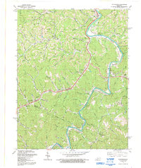
1992 Map of Richardson
USGS Topo · Published 1992About this map
The Levisa Fork winds through this corner of eastern Kentucky, defining the landscape of Lawrence and Johnson counties. In the early 1990s, the area remained a network of hollows and ridges connected by narrow creek-side roads and active industry. Small settlements like Richardson and Lowmansville serve as focal points for local history, surrounded by numerous family cemeteries and country churches including Borders Chapel and Chestnut Grove Ch. The map reveals a high concentration of Gas Wells and several Mines, pointing to the region's long-standing reliance on resource extraction. Waterways such as Georges Creek and Little Blaine Creek weave between the hills, while the Pipeline indicates the vital infrastructure moving energy across the terrain. From the northern hamlets of Blaine and Noris to Whitehouse in the south, the survey documents the enduring rural character and extractive economy of the Appalachians.
Find a feature on this map
78 named features on this map. Tap any name to fly to it.
Don’t see what you’re looking for? This feature index may not catch every label — zoom into the map to look around manually.
Map Details
Editions of this 1992 Richardson Map
This is the sole edition of this map. No revisions or reprints were ever made.
Other maps of this area

1886 · Prestonsburg
USGS Topo · 1:125,000

1892 · Prestonsburg
USGS Topo · 1:125,000

1903 · Kenova
USGS Topo · 1:125,000

1904 · Kenova
USGS Topo · 1:125,000

1911 · Louisa
USGS Topo · 1:48,000

1913 · Louisa
USGS Topo · 1:62,500

1914 · Inez
USGS Topo · 1:48,000

1915 · Paintsville
USGS Topo · 1:48,000

1916 · Inez
USGS Topo · 1:62,500

1917 · Paintsville
USGS Topo · 1:62,500