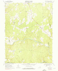
1968 Map of Richardsville
USGS Topo · Published 1976About this map
The Rappahannock River and Rapidan River wind through the heart of the Virginia Piedmont in this survey, forming the natural boundaries between Fauquier, Culpeper, and Stafford counties. The landscape is characterized by a network of small upland settlements and country crossroads like Richardsville, Goldvein, and Sumerduck, connected by winding roads that traverse numerous drainages including Sumerduck Run and Rock Run. Historical social centers are well-represented by several community landmarks such as Oakland Ch, Union Ch, and Clevers Oak Ch.
Find a feature on this map
31 named features on this map. Tap any name to fly to it.
Don’t see what you’re looking for? This feature index may not catch every label — zoom into the map to look around manually.
Map Details
Editions of this 1968 Richardsville Map
3 editions found
Other maps of this area

1887 · Spottsylvania
USGS Topo · 1:125,000

1892 · Spottsylvania
USGS Topo · 1:125,000

1894 · Warrenton
USGS Topo · 1:125,000

1894 · Warrenton
USGS Topo · 1:62,500

1927 · Remington
USGS Topo · 1:48,000

1930 · Warrenton
USGS Topo · 1:62,500

1943 · Catlett
USGS Topo · 1:62,500

1943 · Germanna Bridge
USGS Topo · 1:24,000

1943 · Chancellorsville
USGS Topo · 1:24,000

1943 · Salem Church
USGS Topo · 1:24,000