
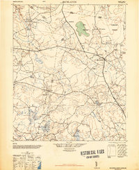
1948 Map of Richlands
USGS Topo · Published 1948About this map
Richlands serves as the focal point of this coastal plain survey, situated where Highway 24 and Highway 258 intersect. The surrounding countryside in Onslow, Duplin, and Jones counties is defined by a complex network of wetlands and small agricultural settlements. To the north, the curiously named Hell Pocosin and Purgatory Pocosin illustrate the difficult, boggy terrain that historically limited large-scale development.
Find a feature on this map
39 named features on this map. Tap any name to fly to it.
Don’t see what you’re looking for? This feature index may not catch every label — zoom into the map to look around manually.
Map Details
Editions of this 1948 Richlands Map
2 editions found
Other maps of this area

1903 · Trent River
USGS Topo · 1:62,500

1904 · Trent River
USGS Topo · 1:62,500

1942 · Burgaw
USGS Topo · 1:62,500

1943 · Jacksonville
USGS Topo · 1:62,500

1943 · Kenansville
USGS Topo · 1:62,500

1948 · Kenansville
USGS Topo · 1:62,500

1948 · Maple Hill
USGS Topo · 1:62,500

1948 · New River
USGS Topo · 1:62,500

1952 · Jacksonville South
USGS Topo · 1:24,000

1953 · Rocky Mount
USGS Topo · 1:250,000