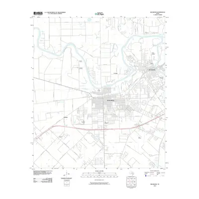
2010 Map of Richmond
USGS Topo · Published 2010About this map
The Brazos River creates a winding natural boundary between the expanding Texas communities of Richmond and Rosenberg. This survey captures the suburban and industrial growth of Fort Bend County, where established neighborhoods meet significant historical infrastructure. The area is notable for its high concentration of family and community burial grounds, such as Morton Cemetery and West Gethsemane Cemetery, which provide a genealogical framework for the local population. Along the river, drainage patterns defined by Seabourne Creek and Jones Creek shape the development of local roads and subdivisions. Small enclaves like Cumings and McHattie persist alongside modern transit hubs like Lane Airpark, illustrating the transition from a traditional river-based economy to a connected regional center.
Find a feature on this map
78 named features on this map. Tap any name to fly to it.
Don’t see what you’re looking for? This feature index may not catch every label — zoom into the map to look around manually.
Map Details
Editions of this 2010 Richmond Map
This is the sole edition of this map. No revisions or reprints were ever made.
Other maps of this area

1915 · Clodine
USGS Topo · 1:24,000

1919 · Clodine
USGS Topo · 1:31,680

1950 · Houston
USGS Topo · 1:250,000

1953 · Needville
USGS Topo · 1:24,000

1953 · Lake George
USGS Topo · 1:24,000

1953 · Kendleton
USGS Topo · 1:24,000

1955 · Sugar Land
USGS Topo · 1:62,500

1955 · Richmond
USGS Topo · 1:62,500

1956 · Houston
USGS Topo · 1:250,000
1970 · Clodine
USGS Topo · 1:24,000