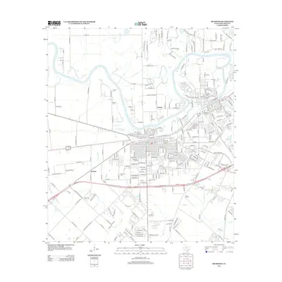
2013 Map of Richmond
USGS Topo · Published 2013About this map
The Brazos River carves a serpentine path through this Fort Bend County landscape, defining the character of the settlements at Cumings and McHattie. The area is notably dense with family and community burial grounds, providing a significant resource for genealogical research. Sites such as Morton Cem, Rosenberg Cem, and Mt Carmel Cem are interspersed among a growing suburban grid. The map also captures the local aviation history at Lane Airpark, situated amidst a network of drainage features like Seabourne Cr and Dry Creek. This 2013 survey illustrates the transition of the region from its agrarian roots—typified by labels like Cottonwood Church RD and Randon School RD—into a more densely populated corridor while maintaining the integrity of its historical landmarks and water-based boundaries.
Find a feature on this map
249 named features on this map. Tap any name to fly to it.
Don’t see what you’re looking for? This feature index may not catch every label — zoom into the map to look around manually.
Map Details
Editions of this 2013 Richmond Map
This is the sole edition of this map. No revisions or reprints were ever made.
Other maps of this area

1915 · Clodine
USGS Topo · 1:24,000

1919 · Clodine
USGS Topo · 1:31,680

1950 · Houston
USGS Topo · 1:250,000

1953 · Needville
USGS Topo · 1:24,000

1953 · Lake George
USGS Topo · 1:24,000

1953 · Kendleton
USGS Topo · 1:24,000

1955 · Sugar Land
USGS Topo · 1:62,500

1955 · Richmond
USGS Topo · 1:62,500

1956 · Houston
USGS Topo · 1:250,000
1970 · Clodine
USGS Topo · 1:24,000