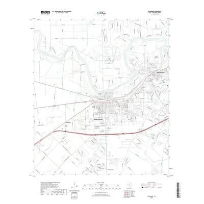
2019 Map of Richmond
USGS Topo · Published 2019About this map
The Brazos River snakes through the heart of Fort Bend County, anchoring the closely linked communities of Richmond and Rosenberg. This survey captures the suburban expansion around these historic centers, showing the transition from traditional riverbank settlements like Cumings and McHattie to modern residential developments. Genealogists will find a high concentration of burial sites throughout the landscape, from the large Morton Cem in the city center to smaller family and organization-linked plots like Lightfoot Cem, McNabb Cem, and the Woodmen of the World Cem. The mapping of local waterways, including Seabourne Cr, Coon Cr, and the Assoc Canal, illustrates the complex irrigation and drainage network that has historically supported the region's agriculture and ongoing development toward the village of Pleak to the south.
Find a feature on this map
241 named features on this map. Tap any name to fly to it.
Don’t see what you’re looking for? This feature index may not catch every label — zoom into the map to look around manually.
Map Details
Editions of this 2019 Richmond Map
This is the sole edition of this map. No revisions or reprints were ever made.
Other maps of this area

1915 · Clodine
USGS Topo · 1:24,000

1919 · Clodine
USGS Topo · 1:31,680

1950 · Houston
USGS Topo · 1:250,000

1953 · Needville
USGS Topo · 1:24,000

1953 · Lake George
USGS Topo · 1:24,000

1953 · Kendleton
USGS Topo · 1:24,000

1955 · Sugar Land
USGS Topo · 1:62,500

1955 · Richmond
USGS Topo · 1:62,500

1956 · Houston
USGS Topo · 1:250,000
1970 · Clodine
USGS Topo · 1:24,000