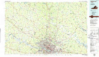
1984 Map of Richmond
USGS Topo · Published 1986About this map
The James River and the Chickahominy River anchor this 1980s planimetric survey, which illustrates the extensive regional growth surrounding Richmond. The urban core is marked by civic and historical landmarks such as the State Capitol and the State Penitentiary, while the expanding suburbs reach north toward Ashland and west toward Midlothian. Academic institutions like Randolph-Macon College and the University of Richmond are clearly situated within their local contexts.
Find a feature on this map
70 named features on this map. Tap any name to fly to it.
Don’t see what you’re looking for? This feature index may not catch every label — zoom into the map to look around manually.
Map Details
Editions of this 1984 Richmond Map
3 editions found
Other maps of this area

1887 · Spottsylvania
USGS Topo · 1:125,000

1889 · Fredericksburg
USGS Topo · 1:125,000

1890 · Goochland
USGS Topo · 1:125,000

1891 · Palmyra
USGS Topo · 1:125,000

1891 · Farmville
USGS Topo · 1:125,000

1892 · Fredericksburg
USGS Topo · 1:125,000

1892 · Spottsylvania
USGS Topo · 1:125,000

1892 · Goochland
USGS Topo · 1:125,000

1892 · Montross
USGS Topo · 1:62,500

1892 · Gordonsville
USGS Topo · 1:125,000