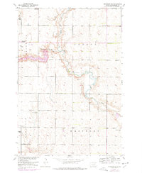
1952 Map of Richmond NE
USGS Topo · Published 1978About this map
The Elm River and its tributary, Willow Creek, dictate the character of this Brown County landscape. This 1952 topography, updated in the late 1970s, captures a rural transition where water management reshaped the plains, evidenced by the Willow Creek Res and the Willow Creek Dam. The prairie is organized into the civil townships of Franklyn, Oneota, Carlisle, and Westport, showing a network of section-line roads connecting family farmsteads and rural infrastructure. A glimpse into the early 20th-century education system is visible through several school sites, including the Union Sch (Abandoned) and Franklyn Sch (Abandoned). These markers, along with the Peck Sch and the Westport Cem, offer essential reference points for genealogists tracing ancestors in the Missouri River Basin development area. Natural artesian features like the Flowing Well and infrastructure such as Kruse Dam further define the local hydrology of the era.
Find a feature on this map
17 named features on this map. Tap any name to fly to it.
Don’t see what you’re looking for? This feature index may not catch every label — zoom into the map to look around manually.
Map Details
Editions of this 1952 Richmond NE Map
2 editions found
Other maps of this area

1894 · Ellendale
USGS Topo · 1:62,500

1894 · Columbia
USGS Topo · 1:62,500

1894 · Savo
USGS Topo · 1:62,500

1896 · Columbia
USGS Topo · 1:125,000

1899 · Ellendale
USGS Topo · 1:125,000

1952 · Ordway
USGS Topo · 1:24,000

1952 · Westport
USGS Topo · 1:24,000

1952 · Richmond NE
USGS Topo · 1:24,000

1953 · Savo SW
USGS Topo · 1:24,000

1953 · Frederick
USGS Topo · 1:24,000