
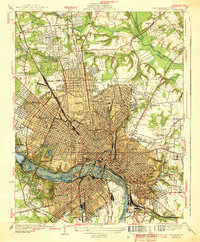
1939 Map of Richmond
USGS Topo · Published 1939About this map
The James River defines the southern heart of the city in this late 1930s survey, with Belle Isle situated between the industrial and residential corridors. This era reveals a dense network of transit and institution, where the Richmond Ashland Electric Ry and major rail lines like the Southern Ry and Seaboard Air Line Ry converge. The landscape is marked by significant cultural and social landmarks, from the State Fair Grounds and City Stadium to prestigious campuses like Virginia Union University and the Union Seminary. Residential growth is evident in planned neighborhoods such as Ginter Park and Windsor Farms. A high concentration of historic burial grounds, including Hollywood Cemetery and Oakwood Cemetery, provides a detailed record for genealogists tracing the city's inhabitants. Northward, specialized facilities like Westbrook Sanitarium and Pine Camp Sanitorium occupy the city's expanding periphery near Joseph Bryan Park.
Find a feature on this map
84 named features on this map. Tap any name to fly to it.
Don’t see what you’re looking for? This feature index may not catch every label — zoom into the map to look around manually.
Map Details
Editions of this 1939 Richmond Map
2 editions found
Other maps of this area

1890 · Goochland
USGS Topo · 1:125,000

1892 · Goochland
USGS Topo · 1:125,000

1894 · Bermuda Hundred
USGS Topo · 1:62,500

1894 · Richmond
USGS Topo · 1:62,500

1895 · Richmond
USGS Topo · 1:62,500

1897 · Amelia
USGS Topo · 1:125,000

1934 · Seven Pines
USGS Topo · 1:24,000

1934 · Richmond
USGS Topo · 1:24,000

1936 · Richmond West
USGS Topo · 1:24,000

1936 · Glen Allen
USGS Topo · 1:24,000