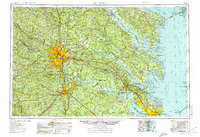
1973 Map of Richmond
USGS Topo · Published 1974About this map
Richmond and the surrounding Tidewater region are defined by the convergence of the James River, York River, and Potomac River as they feed into the Chesapeake Bay. This 1970s survey illustrates a landscape deeply shaped by military presence and historical preservation, featuring significant federal holdings like the Camp Pickett, Fort Lee, and the Dahlgren Naval Weapons Laboratory. Between the urban centers of Petersburg and Newport News, the map preserves the mid-century layout of essential conservation areas, including the Colonial National Historical Park and the Chickahominy River Wildlife Management Area. Inland, the development of water resources is visible through the Swift Creek Reservoir and Lake Chesdin, while coastal features such as Tangier Island and the Chesapeake Bay Bridge-Tunnel highlight the vital connection between the mainland and the Eastern Shore.
Find a feature on this map
174 named features on this map. Tap any name to fly to it.
Don’t see what you’re looking for? This feature index may not catch every label — zoom into the map to look around manually.
Map Details
Editions of this 1973 Richmond Map
2 editions found
Other maps of this area

1887 · Spottsylvania
USGS Topo · 1:125,000

1889 · Fredericksburg
USGS Topo · 1:125,000

1890 · Goochland
USGS Topo · 1:125,000

1891 · Palmyra
USGS Topo · 1:125,000

1891 · Farmville
USGS Topo · 1:125,000

1892 · Fredericksburg
USGS Topo · 1:125,000

1892 · Spottsylvania
USGS Topo · 1:125,000

1892 · Goochland
USGS Topo · 1:125,000

1892 · Piney Point
USGS Topo · 1:62,500

1892 · Montross
USGS Topo · 1:62,500