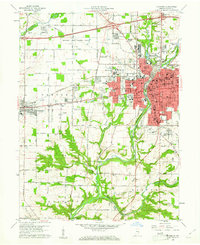
1960 Map of Richmond
USGS Topo · Published 1961About this map
The confluence of the Whitewater River forks anchor the landscape of this 1960 survey, where the expanding urban core of Richmond meets the agricultural lands of eastern Indiana. Significant institutional footprints are visible north of the city at the Richmond State Hospital and the Richmond State Hospital Farm, while the campus of Earlham College serves as a prominent landmark on the western edge of the city. The industrial and transportation identity of the era is clearly marked by the dual corridors of the Pennsylvania and Chesapeake and Ohio railroads.
Find a feature on this map
59 named features on this map. Tap any name to fly to it.
Don’t see what you’re looking for? This feature index may not catch every label — zoom into the map to look around manually.
Map Details
Editions of this 1960 Richmond Map
2 editions found
Other maps of this area

1915 · New Paris
USGS Topo · 1:48,000

1915 · College Corner
USGS Topo · 1:48,000

1918 · College Corner
USGS Topo · 1:62,500

1918 · New Paris
USGS Topo · 1:62,500

1953 · Cincinnati
USGS Topo · 1:250,000

1956 · Brownsville
USGS Topo · 1:24,000

1957 · Cincinnati
USGS Topo · 1:250,000

1960 · Liberty
USGS Topo · 1:24,000

1960 · Fairhaven
USGS Topo · 1:24,000
1960 · Fountain City
USGS Topo · 1:24,000
Featured Places
- Richmond, IN
- Centerville, IN
- Spring Grove, IN
- Spring Grove Heights, Spring Grove
- South Richmond, Richmond