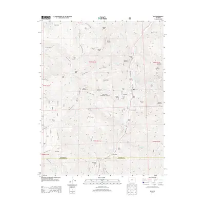
2013 Map of Rico
USGS Topo · Published 2013About this map
Rico occupies a tight valley floor along the Dolores River in the high San Juan Mountains, serving as a hub for the surrounding San Juan National Forest. The 2013 landscape is defined by its dramatic relief, where the town is hemmed in by massive landmarks like Telescope Mountain, Expectation Mountain, and Newman Hill. This era shows a community balanced between its historical roots and modern recreation, featuring the Rico Cem and Rico Ball Park alongside an extensive network of alpine paths including the Calico North Trail 208 and Priest Gulch Trail 645. Geologic instability is a visible factor in the local geography, evidenced by the large Peterson Slide and Spear Slide flanking the river corridor. Further north, the Geyser Warm Spring and Geyser Park represent the thermal activity characteristic of this volcanic region, while the Montelores Bridge marks the southern approach along State Hwy 145.
Find a feature on this map
82 named features on this map. Tap any name to fly to it.
Don’t see what you’re looking for? This feature index may not catch every label — zoom into the map to look around manually.
Map Details
Editions of this 2013 Rico Map
This is the sole edition of this map. No revisions or reprints were ever made.
Other maps of this area

1897 · Rico
USGS Topo · 1:62,500

1897 · Telluride
USGS Topo · 1:62,500

1898 · Engineer Mountain
USGS Topo · 1:62,500

1898 · Rico
USGS Topo · 1:62,500

1899 · Rico
USGS Topo · 1:62,500

1900 · Engineer Mountain
USGS Topo · 1:62,500

1904 · Telluride
USGS Topo · 1:62,500

1908 · Engineer Mountain
USGS Topo · 1:62,500

1945 · Durango
USGS Topo · 1:250,000

1953 · Mount Wilson
USGS Topo · 1:24,000