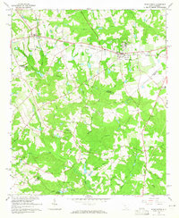
1964 Map of Ridge Spring
USGS Topo · Published 1965About this map
The town of Ridge Spring serves as a central hub on this mid-1960s survey, where the Southern railroad line intersects with old thoroughfares like the Old Plank Road. This agricultural landscape at the tri-county junction of Saluda, Edgefield, and Aiken Counties is defined by a dense network of family-named cemeteries and rural congregations, including Jones Cem, Herin Cem, and Mt Calvary Ch. The topography is shaped by the headwaters of the South Fork Edisto River, with numerous small tributaries like Peters Creek and Lotts Creek feeding into the basin. To the west, the village of Ward sits near Spann Ch, while southern portions of the map reveal timbered areas and landmarks like Yonce Millpond and the Old Trenton Rd. The presence of an Old Railroad Grade and a Lookout Tower suggests a landscape transitioning between early industrial transport and mid-century forestry management.
Find a feature on this map
53 named features on this map. Tap any name to fly to it.
Don’t see what you’re looking for? This feature index may not catch every label — zoom into the map to look around manually.
Map Details
Editions of this 1964 Ridge Spring Map
2 editions found
Other maps of this area

1920 · Aiken
USGS Topo · 1:48,000

1921 · Aiken
USGS Topo · 1:62,500

1923 · Warrenville
USGS Topo · 1:48,000

1928 · Warrenville
USGS Topo · 1:62,500

1943 · Aiken
USGS Topo · 1:62,500

1943 · Warrenville
USGS Topo · 1:62,500

1954 · Augusta
USGS Topo · 1:250,000

1957 · Augusta
USGS Topo · 1:250,000

1958 · Augusta
USGS Topo · 1:250,000

1961 · Augusta
USGS Topo · 1:250,000