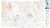
1993 Map of Ridgecrest
USGS Topo · Published 1993About this map
Ridgecrest and the industrial corridors of the Indian Wells Valley define this 1993 study of the high desert. The landscape is dominated by the sprawling operations of the Naval Weapons Center, including NAF China Lake and its associated research infrastructure. To the east, the mineral-rich basin of Searles Lake supports a string of company towns and processing sites such as Trona, Argus, and Westend. This area reveals a complex economy of scale, where vast salt evaporators and Borax Flat meet the technical footprint of Cerro Coso College.
Find a feature on this map
96 named features on this map. Tap any name to fly to it.
Don’t see what you’re looking for? This feature index may not catch every label — zoom into the map to look around manually.
Map Details
Editions of this 1993 Ridgecrest Map
2 editions found
Other maps of this area

1903 · Randsburg
USGS Topo · 1:62,500

1905 · Olancha
USGS Topo · 1:125,000

1906 · Kernville
USGS Topo · 1:125,000

1907 · Olancha
USGS Topo · 1:125,000

1908 · Furnace Creek
USGS Topo · 1:250,000

1908 · Kernville
USGS Topo · 1:125,000

1908 · Ballarat
USGS Topo · 1:250,000

1910 · Furnace Creek
USGS Topo · 1:250,000

1911 · Randsburg
USGS Topo · 1:62,500

1912 · Randsburg
USGS Topo · 1:62,500