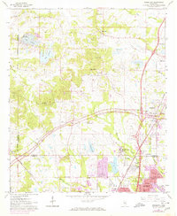
1963 Map of Ridgeland
USGS Topo · Published 1971About this map
Tougaloo Southern Christian College serves as a prominent landmark in this 1960s landscape, reflecting the educational and social history of the region north of Jackson. The geography is defined by a series of man-made water bodies including Lake Lorman, Lake Cavalier, and Lake Castle, which signify the residential and recreational expansion into the northern hills. The historic Natchez Trace Parkway cuts diagonally across the terrain, bridging the gap between old rural outposts and the emerging suburban footprint. Traditional community life is anchored by numerous country churches such as China Grove Ch and New Hope Grove Ch, while the industrial presence of Illinois Central rail lines and scattered Oil Wells highlights the diverse economy. This survey documents the intersection of rural heritage and mid-century growth in the Ridgeland and Madison areas.
Find a feature on this map
57 named features on this map. Tap any name to fly to it.
Don’t see what you’re looking for? This feature index may not catch every label — zoom into the map to look around manually.
Map Details
Editions of this 1963 Ridgeland Map
3 editions found
Other maps of this area

1903 · Jackson
USGS Topo · 1:125,000

1905 · Jackson
USGS Topo · 1:48,000

1908 · Jackson
USGS Topo · 1:62,500

1934 · Raymond
USGS Topo · 1:48,000

1937 · Raymond
USGS Topo · 1:62,500

1942 · Raymond
USGS Topo · 1:62,500

1955 · Jackson
USGS Topo · 1:250,000

1961 · Jackson
USGS Topo · 1:250,000

1961 · Canton
USGS Topo · 1:62,500

1962 · Jackson
USGS Topo · 1:250,000