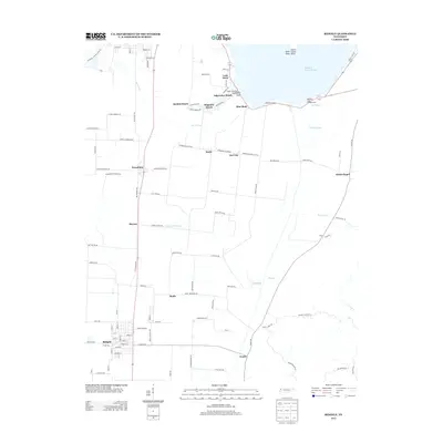
2013 Map of Ridgely
USGS Topo · Published 2013About this map
The town of Ridgely anchors the southern portion of this landscape, situated at a junction of roads and rail lines that once drove the regional economy. Moving north toward the shoreline, a string of lakeside communities including Sunkist Beach, Magnolia Beach, and Edgewater Beach defines the boundary where land meets the water. This 2013 survey illustrates a transition from the structured grid of the town center to the irregular, seasonal settlement patterns along the lakefront. Local navigation and commerce are marked by features like Lovells Boat Dock and Kirks Camp, while inland names like Wynnburg, Madie, and Haynes indicate the established agricultural hamlets of Lake County. The map provides a detailed view of the complex hydrography of the area, featuring named water bodies such as Reading House Slough and Box Slough, which weave through the terrain and influence the placement of early roads like Free Bridge Rd and Wynneburg-Owl City Rd.
Find a feature on this map
104 named features on this map. Tap any name to fly to it.
Don’t see what you’re looking for? This feature index may not catch every label — zoom into the map to look around manually.
Map Details
Editions of this 2013 Ridgely Map
This is the sole edition of this map. No revisions or reprints were ever made.
Other maps of this area

1925 · Reelfoot Lake
USGS Topo · 1:62,500

1939 · Reelfoot Lake
USGS Topo · 1:62,500

1939 · Portageville
USGS Topo · 1:62,500

1939 · Dyersburg
USGS Topo · 1:62,500

1939 · Caruthersville
USGS Topo · 1:62,500

1951 · Caruthersville
USGS Topo · 1:62,500

1952 · Lane
USGS Topo · 1:24,000

1952 · Miston
USGS Topo · 1:24,000

1955 · Portageville
USGS Topo · 1:62,500

1956 · Reelfoot Lake
USGS Topo · 1:62,500